 |
| abandon Bard Ave. Tracks |
 |
| The South Beach stop that used to bring people to Happy Land Park. |
 |
| There is nothing left of this station that stood next to Father Capp | . Wentworth 1949 |
|
 |
| Sand Lane in the 1930's |
 |
| Arrocher Train Station |
 |
| Newer Belair Station 1937 |
 |
| Workers working on the Chestnut Ave stop and you can see the Bachmann station behind them |
 |
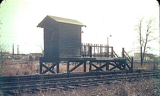
| This is the Wentworth Ave Train Station. It was the last stop on the South Beach line its only purpose was to take people a little bit further then the South beach stop. It was only able to accommodate one door of one car. It was only added after SIR electrified its 3 lines in 1925. |
 |
| The Arlington Yard |
Staten Island Advance Tuesday, March 31, 1953
The Old Order Passeth - Rails Surrender To Roads
Once there were many cars on the trains- but that was years ago-
and now there are many cars in the ferry terminal parking lot.
Buses and autos will kill off the SIRT's North Shore and South Beach lines
in a cloud of monoxide tonight at midnight,
when the railroad ends service on those runs in the face
of a steadily mounting loss in passenger traffic.
Passenger Runs On Two Lines Of SIRT Will End At Midnight –
Buses are added on North, East shores
Sixty seven years of rapid transit on the island's
north and east shores will come to an end at midnight tonight.
The SIRT, in conformity with a ruling from the
Public Service Commission, will suspend it's passenger service to
South Beach and Arlington, retaining only it's south shore branch to Tottenville.
City buses are in readiness to fill the gap.
Thirteen extra vehicles have been added to the
Richmond terrace and Bay street routes during rush hours
to carry an estimated 1,200 commuters who no longer can use the railroad.
The last train to Arlington will leave St. George
at 11:30 PM arriving at the railroad yard 16 minutes later.
At 11:36, the final passenger train to travel over north shore track
will leave the Arlington terminal for St. George pulling in at 11:53
On the east shore, the last train will get underway from St. George at 11:15,
rolling into the Wentworth Avenue station, South Beach at 11:30.
Nine minutes later it will start the final trip to St. George,
arriving five minutes before midnight.
The curtailment of passenger service will mean a loss of jobs
 |
| Again the abandoned or "razed" Arlington Station |
to more than 40 SIRT employees. Stations on the two lines
will be closed down and probably razed eventually.
 |
| New and improved Rosebank Station. |
.
 |
This is a view of the original Elm Park Station in 1932 before the grade elimination |
.
 |
| Clifton Station |
 |
| The Last day of service for the North Shore line. This is the Arlington stop. |
|
|
 |
| Taken by someone walking over the overpass at Elm Park. |
 |
| Abandoned Lake Ave stop. |
 |
| The old rock tunnel |
 |
| Elm Park. |
 |
| The is the Rosebank Station looking out towards South Beach. That house is still there, this pic was takin in 1913 |
 |
| a abandoned Rosebank station in the 60's |
 |
| This was a underpass for people to walk under the tracks and cross over to the otherside PS13 in the background |
 |
| Arrocher Train station in the 30's |
 |
| Abandoned Port Richmond Station |
|
 |
The Procter & Gamble Company constructed their third factory in the Staten Island neighborhood of Milliken. This plant would begin construction in early 1906, and would open in 1907. The neighborhood of Milliken would eventually be renamed Port Ivory, in tribute to Ivory Soap, one of the best-known products from Procter & Gamble.
The Procter & Gamble Port Ivory factory was located at Richmond Terrace and Western Avenue. This is in close proximity to the present day Howland Hook Marine Terminal / New York Container Terminal.
|
 |
A photo of the original Elm Park station. 1928Thank you to this guy. most of the pictures came from there.
I have heard that there has been talking about opening up the North Shore Arlington line again. It would cost about 400 million dollars, but considering the lack of money were getting back from current buses and such, it may be a good idea. We would probably get much more use out of it now then they did back then.
Here is the complete line map. You can see all 3 lines, even the Mt. Loretto Stop. I tried to put all these pictures in order but blogspot wont let me arrange them :( |


Howdy and like wow! This is "That Guy"! Yee haa! :)
ReplyDeleteI like your little page and thank you for giving me credit for many of the photos! I am forever in search of photographs of both the south beach and north shore lines. If you ever come across any that you think I may be interested in, please let me know.
By the way, the photo you have listed as "Abandoned Arlington Station" is incorrect. Forgotten New York has it listed as such (he took the photo) but that is a shot of the abandoned Port Richmond station. The Arlington station/terminus was a long wooden building and was not elevated. It was long gone by the late 1950's.
Thanks again!
:)
GretschViking
I just discovered two more errors. The first shot you have of the tracks at Snug Harbor is actually near Bard Avenue where the Livingston station once stood. The second is the photo that states: "again, the abandoned or "razed" Arlington station" is actually a shot of the dead Mariners Harbor station.
ReplyDeleteohhh thank you lol its hard when you dont take the actual pictures to know exactly where they were taken .. and i have never seen these places thought i would like to the weather is not permitting right now im going to in spring and track them all down. Glad you like my site <3
ReplyDeleteHello! It's me again! :)
ReplyDeleteYes. The weather hasn't been up to par but wait until early Spring when there are still no leaves on the trees. This will help you see more of what's on the Right Of way. Just be careful wandering around down there as nowadays it's rather treacherous in places.
One more correction. The photo from above the Elm Park station was taken from the walkway of the Bayonne Bridge.
:)